


A relatively deep offshore earthquake struck the Indonesian archipelago late on Friday, August 17, according to data from the US Geological Survey.
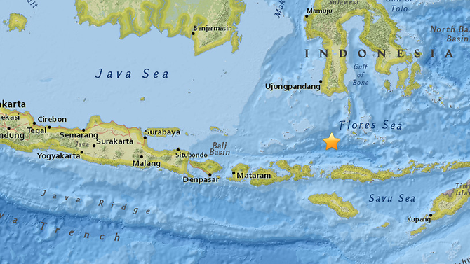
The U.S. Geological Survey said the quake had a preliminary magnitude of 6.5 and was located 109 kilometres northwest of the village of Kampungbajo in central Indonesia at a depth of 539 kilometres. Deep earthquakes generally cause less damage.
Indonesia’s Meteorology, Climatology and Geophysics Agency (BMKG) said in a tweet there was no tsunami risk.
Netizens took to social media to share news about the earthquake, with some saying they had felt it in Bali, about 580 km from Raba.
This strong #earthquake was felt in Flores Sea, Bali Region, Indonesia, Java, Indonesia, Bali Region, Indonesia
— EMSC (@LastQuake) 17 August 2018
The epicentre of Friday’s quake was around 500km from the island of Lombok, where two deadly tremors – and dozens of aftershocks – wreaked widespread damage earlier in the month.
A magnitude-6.2 earthquake rocked Lombok on Aug 9, sparking panic after a powerful earthquake just four days earlier.
Source: Channel News Asia
Photo courtesy of USGS