


The Meteorology, Climatology, and Geophysics Agency (BMKG) has stated that the impact of Cyclone Seroja could potentially still be felt in West Nusa Tenggara (NTB), Bali, East Java, Central Java, and Yogyakarta, in a statement from the Tropical Cyclone Warning Centre (TCWC).
“There is potential for moderate to heavy rain accompanied by lightning and strong winds in Central Java, Yogyakarta, East Java, Bali and West Nusa Tenggara, as well as moderate-intensity rain in East Nusa Tenggara,” said BMKG Deputy for Meteorology, Guswanto.
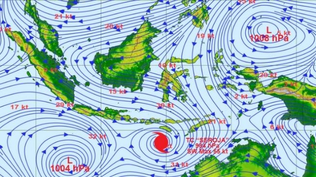
Based on BMKG’s monitoring, currently, the Seroja cyclone is in the southwestern Indian Ocean, precisely at 12.3 south latitude, 118.8 east longitude, or about 465km southwest of Waingapu.
However, the Head of BMKG Dwikorita Karnawati has predicted that the weather after 7th April will get better, along with a shift in course of Cyclone Seroja detected in the waters around East Nusa Tenggara.
Even though the weather situation is predicted to get better, Dwikorita has reminded people that ocean waves still have a high potential for damage.
“So, you have to be careful in the oceans, even though the land will be calmer, the waves will still be higher,” he warned.
Dwikorita explained that since 2nd April, BMKG has detected the existence of Tropical Cyclone Seed 99S, or Cyclone Seroja.
“This Cyclone Seroja information will be immediately disseminated to various departments, including to local governments in potentially affected locations and BMKG stations in the affected areas,” he said.
The existence of these tropical cyclone seeds has caused significant extreme weather in the form of very heavy rain, strong winds, and high waves. They have also had an impact on the occurrence of hydrometeorological disasters in several areas in East Nusa Tenggara.
“There are seven BMKG stations which we are currently working with to get to refugee camps, in order to explain what is happening to calm the residents and also to make a WhatsApp refugee group so that weather developments and early warnings can be spread through this platform,” he explained.
Regarding reports of tsunami predictions in the East Nusa Tenggara region, the Head of the Tenau Meteorology Station of the Geophysical Meteorology Climatology Agency, Syaeful Hadi, said this information is a hoax. As a result of this incorrect information, residents in the coastal area of ??Kupang ran out of their homes to seek shelter in an elevated area in the early hours of Wednesday.
According to Syaeful, high waves and significant rainfall could affect coastal dynamics in a number of East Nusa Tenggara marine areas. He said that waves as high as 1.25-1.5 metres are likely to occur in the southern part of the Sape Strait, the western Sumba Strait, the Savu Sea, the Ombai Strait, the northern waters of Kupang, and at Rote Ndao.
Wave as high as 2.5-4 metres are likely to occur in the southern waters of Kupang and Rote Ndao, in the Indian Ocean south of Kupang and Rote Ndao. In addition, was reaching up to 4-6 metres are likely to occur in the Indian Ocean south of Sumba and Sabu Raijua.
Syaeful has appealed to the people of the coastal areas of Kupang and other potentially affected areas to be aware of the phenomenon of coastal flooding.