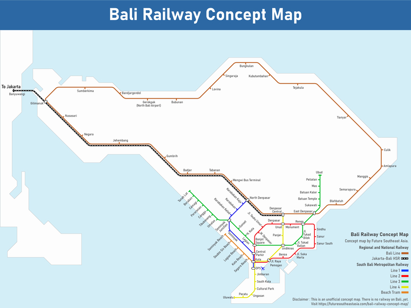
In a series of proposals spanning over a decade, plans for a comprehensive Bali railway network have been unveiled.
The Bali Railway Network, meticulously archiving every announcement since at least 2011, serves as a testament to the persistence of this ambitious project.
To provide a visual representation of the proposed Bali rail system, a detailed Bali Railway Concept Map has been released. This conceptual map outlines the intricacies of a railway system encompassing an island circle line, a high-speed connection to Java, and an urban rail transit system in South Bali.
This conceptual map amalgamates previous proposals and introduces new recommendations. The delineation between long-distance railways and metro railways is clearly articulated, with accompanying news links for each proposal detailed below.
Regional and National Railway
This segment encompasses provincial and national railway services.
Bali Line
The Bali Line proposes a circular railway around the entire island, inspired by the 2011 National Railroad Master Plan by the Ministry of Transportation. While earlier maps suggested a three-quarters circumference, recent plans, championed by President Joko Widodo in 2017, advocate for a complete circular route. This strategic line could potentially service a station near the envisaged second Bali airport, initially slated for Kubutambahan before relocation to Gerokgak and subsequent project postponement.
The Bali Line integrates previously proposed routes designed to connect with the second Bali airport, which was originally planned for Kubutambahan.
Jakarta-Bali High-Speed Railway
Linking Denpasar to Gilimanuk, a Bali-Java High-Speed Railway is envisaged, contingent upon the construction of a proposed Bali-Java Bridge. If materialised, this railway would intersect with the Jakarta-Bandung High-Speed Railway, though challenges arise due to the latter’s 350km/h speed, necessitating adjustments to accommodate the Bali connection.
South Bali Metropolitan Railway
This section focuses on urban transit railways, encompassing metro, light rail, and tram systems.
Line 1 (Seminyak Line)
Under consideration since 2022, Line 1 proposes a train route from Ngurah Rai Airport to Seminyak. While specific details remain scant, a November 2022 report suggests a preference for an LRT model with underground segments, mirroring Legian Road’s route on the conceptual map.
Line 2 (Denpasar Loop)
Running from the airport to Denpasar, Renon, Sanur, and Benoa, Line 2 is the second proposed route alongside the Seminyak Line. A conceptual map based on available information outlines the potential path.
Line 3 (Ubud to Tanah Lot)
In 2017, Chinese investors were offered a Bali railway project, including a line from Denpasar to Ubud and Singaraja. Line 3, depicted on the conceptual map, extends westward to Tanah Lot via Sunset Road, connecting popular tourist destinations and offering relief to traffic congestion in the Umalas and Canggu areas.
Line 4
Connecting Denpasar Central to points in Denpasar and Kuta, Line 4 diverges from the original 2011 plan, opting for a route south of the airport to Garuda Wisnu Kencana Cultural Park, Ungasan, Pecatu, and Uluwatu.
Beach Tram
Despite being a fantasy addition to the map, the Beach Tram proposal, showcasing images at Double Six Beach, captures the imagination. Imagined to start at Kuta Station, the tram would serve as a crucial interchange hub, reinforcing Kuta’s position as a major transit hub.
While these plans represent an ambitious vision for Bali’s railway future, the logistical and financial challenges associated with their implementation remain significant. As discussions continue, the prospect of a comprehensive and efficient Bali railway network continues to capture the interest of locals and tourists alike.


